Routes
Monte Pavón route in Gran Canaria: complete trail guide
A circular trail among farmhouses, cheese dairies, and wet pastures in the north of Gran Canaria, with very green landscapes.

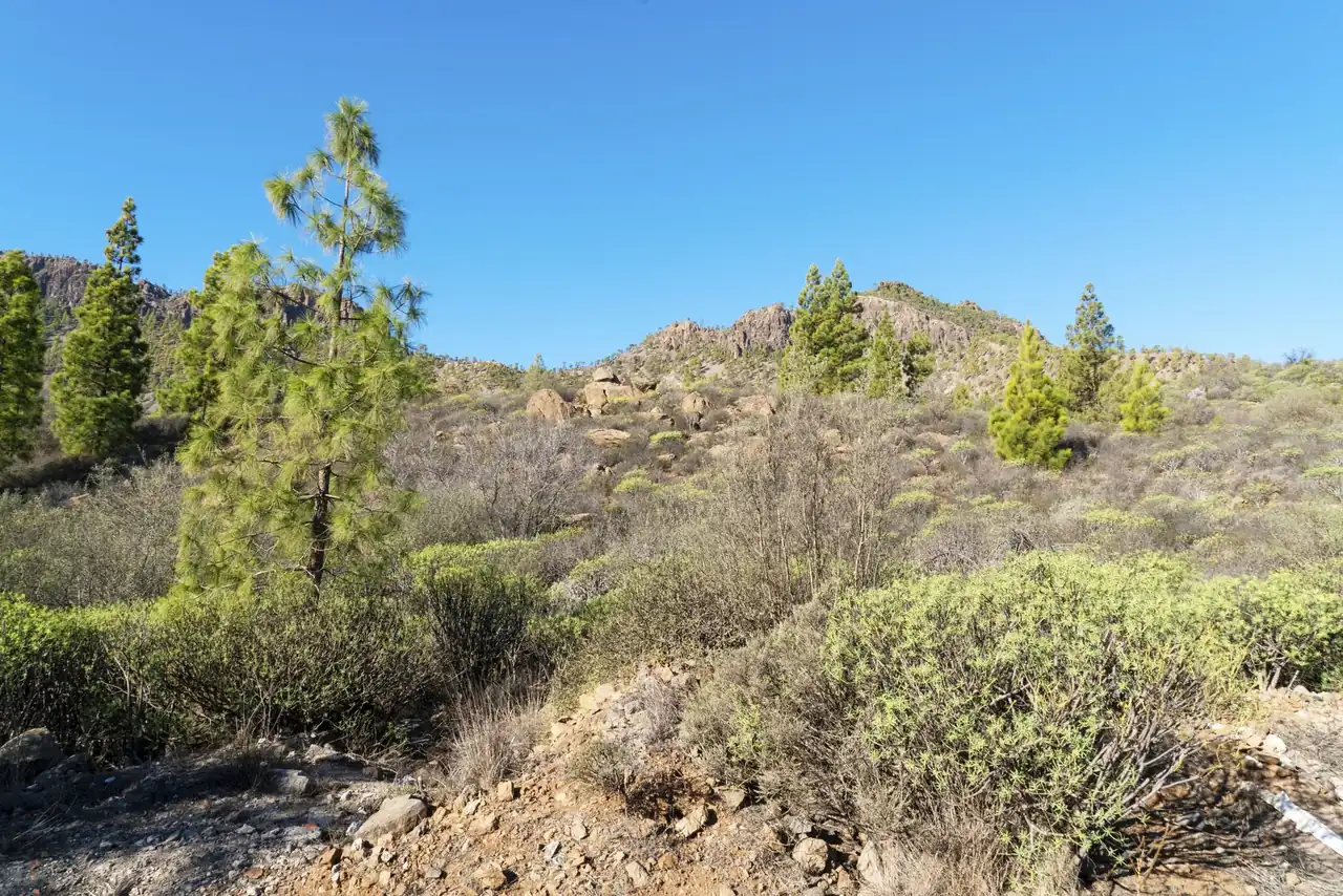
Monte Pavón sketches one of those northern Gran Canaria landscapes that changes face with the rain: pastures blazing green, low fog, the smell of damp earth, and fenced enclosures where livestock still sets the rhythm of the territory. The circular route starting in Montaña Alta crosses a rural mosaic of farmhouses, pines, and fincas that explains better than any postcard why this area has earned a reputation as the small Canary Irish countryside.
In this mid-altitude stretch of Santa María de Guía, the walk is not just about adding kilometers. It brings together agricultural landscape, livestock heritage, and open views over a strip of the island where human work can still be read in every stone wall, every gate, and every fence that the trail requires you to open and close patiently. It is a route that is generally easy to follow, but with nuances worth knowing so you can enjoy it without surprises.
A rural landscape that is still alive
The first impression of Monte Pavón is usually the humidity. Even on mild days, the air feels fresh and has a mountain clarity that makes you think of a different island, more Atlantic and more northerly. After the rains, the meadows turn into a thick blanket and the young pines contrast with the ocher tones of the nearby hills. When the sky opens, the scene changes quickly, and the path moves from the dimness of the mist to the clean brightness of the heights.
That character is part of its appeal. This is not just a walk in the countryside, but a journey through an area where livestock and cheesemaking activity are still present. The sheep are not decoration; they are part of the real use of the land, and so the walker encounters fenced crossings, gates, and farms that remind you that the trail shares space with a living rural economy. Respect for that environment is just as important as the GPS itself.
The popular nickname of the small Ireland of Gran Canaria is not a marketing exaggeration, but a fairly accurate way to describe the visual contrast. The intense green is no accident: it is sustained by altitude, terrain orientation, and the constant action of the trade winds. At around 1,000 to 1,300 meters, the climate becomes more unpredictable than on the coast, but also much richer in sensations. The route thus gains an almost scenic dimension, with changes in light that seem layered together.
Where to stay near Santa María de Guía
Accommodation in the area, with prices. Choose your dates on the map.
Affiliate links: if you book through this map we earn a commission, at no extra cost to you.
The route between Montaña Alta and the recreational area
The departure from Montaña Alta sets the tone for the day from the very first step. The start usually runs along asphalt for a short stretch before entering dirt paths and rural tracks, with the village church and the surroundings of the GC-70 as easy reference points. From there, the route heads into gentle hills and crossings that are unevenly marked, so having the itinerary downloaded before setting out is a prudent choice, not a tech obsession.
The path advances along dirt trails, tracks, and small asphalt sections, with a more demanding initial climb that later softens. The terrain rarely presents serious technical difficulty, but it can change a lot depending on the time of year. When the ground is wet, mud and loose gravel turn some sections into a small balancing exercise; in summer, by contrast, the trail usually dries out and becomes faster, although the landscape loses part of its emerald intensity.
One of the most recognizable points is the area around the Monte Pavón recreational area, a broad and very useful space for understanding the life of Guía’s lower highlands. There the route skirts part of the area without needing to cross it completely, although it is worth knowing that the itinerary may vary depending on the version followed. Some traces become complicated by vegetation, while others better skirt the enclosure, with a more comfortable logic and less exposure to dense scrub.
Distance, elevation gain, and real time on the trail
The most reliable data puts the distance at around 9 kilometers, with elevation gains that roughly range between 300 and 670 meters depending on the measurement and the exact track followed. That range explains why different sources give slightly different figures. In the mountains, the exact number is never as important as the context: the surface, the weather, the pace, and the breaks matter far more than a few tenths up or down.
In terms of time, the most sensible reference is between 3 and 4 hours for a relaxed pace with normal stops, although at a brisk pace it can be done somewhat faster. Here too, the terrain is the deciding factor. Some people turn it into a leisurely outing, with a sandwich and long looks around, while others use it as endurance training thanks to its mix of flat sections, steady climbs, and continuous descents. For trail runners, this profile can be especially interesting as an aerobic base day without excessive technical difficulty.
The maximum altitude is around 1,300 meters, while the lowest point drops comfortably below 900 meters on some tracks. That range, though not extreme, is enough for the climate to change noticeably. On cold mornings, the air cuts. On days with low cloud, the feeling is almost that of high Atlantic mountain. And when the sun beats down, the contrast with the damp vegetation increases the sense of freshness in certain stretches.
Terrain, footwear, and gear that make the difference
The trail does not demand high-mountain technical gear, but it also does not reward improvisation. Shoes with good grip are much more sensible than city footwear, especially if the ground is wet or there are slippery gravel sections. Anyone who has walked humid mid-altitude paths knows that Canary mud can seem innocent until it steals a foothold on a bend. There, traction is worth its weight in gold.
It is also advisable to carry enough water and a light windbreaker. Even on a relatively short route, wind and humidity can cool the body quickly. Mobile coverage is not always reliable, so it is wise to open the track before entering stretches where the signal weakens. This is not a route where you can rely on your phone to solve everything by itself, because some crossings are not as clearly marked as one would like.
There is also a very practical detail: several passages are affected by livestock. It is common to find fences or gates that must be opened and then closed again. That gesture, which in a city would seem unusual, is here part of the cultural landscape. It is not an annoyance, but a sign that the land is still in use. The route works best when the walker understands and accepts that coexistence without drama.
Monte Pavón in winter, spring, and summer
The season completely changes the reading of the itinerary. After the rains, Monte Pavón becomes more cinematic: the green deepens, the ravines sharpen with moisture, and the low clouds create layer upon layer of depth. This is when the landscape gains fame and when the comparison with northern mainland regions stops being an exaggeration and becomes a fairly accurate impression, though with the always different light of the Canary Islands.
In spring, the route retains much of that freshness and adds a very pleasant balance between color and temperature. It is probably the most enjoyable time to walk it at a leisurely pace. Summer, on the other hand, reduces the chromatic contrast and reveals the agricultural structure of the land more starkly: farms, hills, dried pastures, and pine groves that seem more austere. Even so, if it does not coincide with periods of intense heat, it remains a relatively cool area thanks to the altitude.
Winter, for its part, can offer the best scenes and also the greatest precautions. Mud builds up, low fog reduces visibility, and stretches with gravel or slope become more delicate. But it is precisely in that setting that the route acquires its greatest personality. The farmhouses seem older, the sheep quieter, and the mountain more like a film in green and white than an ordinary walk.
What you really see during the hike
Beyond the map, the richness of this itinerary lies in the succession of small scenes. You will see flocks of sheep, dry-stone walls, paths between farms, and tall pines, as well as openings from which the view extends toward northern Gran Canaria. At times, the trail seems to glide along a page of rural geography; at others, it feels like a narrow corridor between damp hills where silence weighs as much as the incline.
The area of the Pinos de Gáldar brings a very striking plant dimension. The centuries-old specimens and the nearby protected surroundings reinforce the feeling of walking under a canopy of vegetation with memory. This is not a dense textbook forest, but an intermediate, open, breathable landscape where pine woodland coexists with pastures and mid-altitude vegetation. That mix is one of the keys to the route and also one of the reasons so many hikers remember it so clearly.
On clear days, the horizon may even reveal the silhouette of Teide, a reminder that from the northwest of Gran Canaria the gaze travels beyond the island itself. Of course, it does not always appear, and even less so when haze or mist erases distances. But when it does, the hike gains an almost theatrical backdrop. The landscape ceases to be local and becomes an Atlantic balcony.
The value of starting in Montaña Alta and finishing with cheese
One of the charms of this route is that it does not end with the simple achievement of completing the loop. Montaña Alta allows you to close the day with a visit to the 360-degree viewpoint and a stop at the House of Cheese, very close to the starting and ending point. That combination turns the outing into a complete rural experience, where hiking, landscape, and local cuisine fit together naturally.
Guía cheese, especially the kind made with vegetable rennet, is part of the place’s story just as much as the farmhouses or the sheep. The municipality’s cheesemaking tradition is felt along the route almost like a gentle shadow: the farms, livestock, and dairies give meaning to what you see. This is not just a pretty path; it is a productive territory with a very marked identity and a cheese culture that still sustains part of its appeal.
The nearby recreational area also reinforces the idea of a full-day outing. The tables, parking, and facilities make the surroundings a useful place to spend an entire day without complicating the logistics. For anyone coming from another part of the island, this has a clear advantage: the walk does not depend on improvised solutions. It can be combined with a quiet meal, a visit to the viewpoint, or a long break at the end of the route.
A route demanding just enough to be worthwhile
The best definition of this hike may be this: accessible, varied, and full of character. It does not seek the drama of the great peaks or the vertigo of a ravine, but neither does it fall into the monotony of overly flat trails. It has climbs, descents, asphalt, dirt, pasture sections, and passages that require attention. That mix gives it a gentle tension, enough for the body to work and the mind not to switch off.
From the point of view of a trail runner or regular hiker, Monte Pavón works as training with scenery. It lets you accumulate elevation without excessive load and offers a useful surface for testing paces, controlling effort, or simply moving through a friendly environment. The key is not to underestimate the mud, not to be overconfident on the descents, and not to assume that all crossings are easy to read at first glance.
Most valuable of all, however, is the feeling of authenticity. In a time when many trails seem designed for the quick photo, this one retains a less flashy and much more interesting quality: that of a real rural path, inhabited by livestock, agricultural work, and a geography that has not been turned into a backdrop. That is the real reason why Monte Pavón stays in the memory of anyone who walks it calmly.
When the north of the island becomes landscape and craft
There are routes remembered for a summit and others for a single surprise. Monte Pavón stays in the mind for the whole package: the green after the rain, the smell of damp earth, the fences that open and close, the scattered huts, the pine grove, the mist, and the calm of a municipality that still keeps the rhythm of worked mid-altitude land. This is not a quick-consumption setting; it is a territory that asks for attention.
That is why this circular route has so much editorial strength. It sums up northern Gran Canaria in a compact format: landscape, livestock, mid-altitude terrain, cheesemaking tradition, and a beauty that needs no exaggeration. Anyone looking for a hike with its own identity will find here an honest itinerary, firmly tied to the land and capable of offering much more than a sequence of meters. Monte Pavón is not just seen; it is read.
And that reading changes with each season, each rainfall, and each cloud that decides to spend the night on the slope. Therein lies much of its magnetism: it is never exactly the same route, even if the map seems to repeat itself. Each loop confirms that, in Gran Canaria, the mountain closest to the north can feel like an island within the island.



How to prevent thigh chafing: causes and real solutions

Women’s running windbreakers: seven jackets and how to choose

Do more workouts get rid of soreness? A guide for runners

Jaén Half Marathon 2026: Record 3,800 Runners Registered

Men’s short running tights: how to choose the right pair

World Triathlon confirms data breach involving medical data

Izan Edo targets podium at Miyazaki World Cup

María Pérez ranks ninth in World Athletics’ 2026 top ten

Dos Santos, Duplantis and Sawe: World Athlete of the Year finalists

San Silvestre Vallecana 2026: 42,000 places, prices and start times

 Races3 months ago
Valencia Half Marathon 2027: date and registration

 Races3 months ago
Valencia Marathon 2026: entry, ballot and course

 Reviews and Comparisons4 months ago
Asics Gel-Roadmiles 3 for men: review and current price

 Reviews and Comparisons4 months ago
Asics Gel Sonoma 8 Gore-Tex: complete analysis for trail and rain

 Sneakers3 months ago
Saucony Endorphin Pro 4: full review and verdict

 News5 months ago
Strava API 2026: what changes for clubs, challenges and runner apps?

 Reviews and Comparisons5 months ago
Nike Alphafly 3: opinions, sensations, and real key points

 Reviews and Comparisons4 months ago
Under Armour running shoes review 2025-2026: models and key features

 Sports Equipment4 months ago
Shoe sizes in cm: a clear guide to getting the right fit for your footwear

 Sneakers3 months ago
Skechers GO RUN Consistent 2.0 analysis: comfort and limits

 News5 months ago
Valencia Marathon 2026 route: key tips to train and run better

 Sneakers4 months ago
Adidas Adizero Boston 13 for men: review and verdict